1954 Jacques Branger Pictorial Map of Asia (Messageries Maritimes) 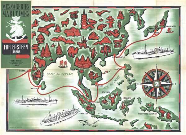 WE SELL ONLY ORIGINAL ANTIQUE MAPS - NOT REPRODUCTIONS Title: Messageries Maritimes Far Eastern Liners Description: This is a 1954 Jacques Branger pictorial map advertising Messageries Maritimes route through East Asia. The map depicts Asia from India to Japan and New Guinea and from Mongolia and Korea to extreme northern Australia. This map highlights the three newly-christened ships which serve the Indo-Chinese and Far East market, the Cambodge (French for Cambodia), the Laos, and the Viet-Nam. The month long voyages began at Marseille, and then called at Port Said and Aden (which are not on the map), then at Bombay, Colombo, Singapore, Saigon, Hong Kong, Kobe (only on the eastbound voyage), and Yokohama. Numerous vignettes decorate the map, including Angkor Wat, a woman in traditional Thai dress, a Chinese dragon, an elephant and a snake charmer in India, and a kangaroo in Australia. Depictions of the Cambodge, Laos, and Viet-Nam are also present. This map was designed by Jacques Branger and published by Messageries Maritimes in 1954. Size: Printed area measures 21.5 inches high by 28.5 inches wide. Condition: Very good. Wear along original fold lines. Minor fold separations professionally repaired on verso. Text and photographs on verso. Shipping: Shipping rates are not negotiable. Items are shipped within three business days of receiving payment. We are happy to consolidate shipping where possible. The following shipping options are available: 1. FedEx Overnight (45 USD). USA Only. Signature Required. Customs: International buyers are responsible for paying duty and taxes on delivery. DHL or FedEx will contact the buyer by telephone to arrange tax payment if it is levied. Duty varies by country and we cannot predict the amount you will be charged. Some countries are duty free, others are not. Typically, a customs duty and/or VAT tax will be assessed on all parcels to continental Europe. Sometimes duty or tax is due in China, but is seems very random. Hong Kong, Singapore, Korea, and Taiwan have never assessed duty on a map we shipped. Maps shipped to the UK should be duty free as educational materials, but from time to time duty of 5% is assessed incorrectly by the UK customs agents. Insurance: All shipments are insured privately against loss and damage. All of our shipments require a signature for insurance purposes. If you have any questions please feel free to email us through eBay. Other Services Conservation Framing: Geographicus recommends basic conservation framing services for any antique paper. We do not offer this service. |

1954 Jacques Branger Pictorial Map of Asia (Messageries Maritimes) WE SELL ONLY ORIGINAL ANTIQUE MAPS - NOT REPRODUCTIONS Title: Messageries Maritimes Far Eastern Liners Description: This is a 1954 Jacques Branger pictorial map advertising Messageries Maritimes route through East Asia. The map depicts Asia from India to Japan and New Guinea and from Mongolia and Korea to extreme northern Australia. This map highlights the three newly-christened ships which serve the Indo-Chinese and Far East market, the Cambodge (French for Cambodia), the Laos, and the Viet-Nam. The month long voyages began at Marseille, and then called at Port Said and Aden (which are not on the map), then at Bombay, Colombo, Singapore, Saigon, Hong Kong, Kobe (only on the eastbound voyage), and Yokohama. Numerous vignettes decorate the map, including Angkor Wat, a woman in traditional Thai dress, a Chinese dragon, an elephant and a snake charmer in India, and a kangaroo in Australia. Depictions of the Cambodge, Laos, and Viet-Nam are also present. This map was designed by Jacques Branger and published by Messageries Maritimes in 1954. Size: Printed area measures 21.5 inches high by 28.5 inches wide. Condition: Very good. Wear along original fold lines. Minor fold separations professionally repaired on verso. Text and photographs on verso. Shipping: Shipping rates are not negotiable. Items are shipped within three business days of receiving payment. We are happy to consolidate shipping where possible. The following shipping options are available: 1. FedEx Overnight (45 USD). USA Only. Signature Required. Customs: International buyers are responsible for paying duty and taxes on delivery. DHL or FedEx will contact the buyer by telephone to arrange tax payment if it is levied. Duty varies by country and we cannot predict the amount you will be charged. Some countries are duty free, others are not. Typically, a customs duty and/or VAT tax will be assessed on all parcels to continental Europe. Sometimes duty or tax is due in China, but is seems very random. Hong Kong, Singapore, Korea, and Taiwan have never assessed duty on a map we shipped. Maps shipped to the UK should be duty free as educational materials, but from time to time duty of 5% is assessed incorrectly by the UK customs agents. Insurance: All shipments are insured privately against loss and damage. All of our shipments require a signature for insurance purposes. If you have any questions please feel free to email us through eBay. Other Services Conservation Framing: Geographicus recommends basic conservation framing services for any antique paper. We do not offer this service. |

